Drone-powered site modeling reduces risk, reinforces schedule accuracy
By Dominic Corrado
Without an accurate, holistic image of your starting position and careful tracking along your journey, how can you ensure you stay the course and reach your intended destination?
In preparation for vertical construction, excavation and backfill can entail a significant amount of risk when the requisite volumes are based on estimates. So many elements of further procurement and planning depend on an accurate estimate of the total earthwork to be moved or removed, and even small fluctuations can have lasting impacts.
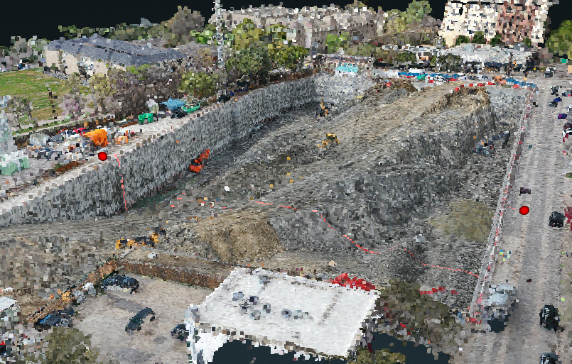
To mitigate risk, our teams have been deploying imaging drones to create accurate, 3D models of projects sites, enabling precise calculations of earthwork volume and every possible downstream effect. With eyes in the skies, the latest in 3D site modeling tools and technology teams able to combine these advantages, superintendents are better prepared and fully empowered to keep projects on-schedule and on-budget.
Our own technology teams also enhance the modeling process with overlays of project data, leading to a robustly coordinated system of project data layers. By plying every possible advantage out of a carefully gathered and collated set of data, projects are set up for success, as well as support trade partners looking to expand their capabilities in the drone imaging and 3D modeling spaces.
Model-making for reliability
Facts, figures and dimensions all inform sitework and excavation decision-making. What kind of earth are we moving? How much of it is there? Where will it go, and in what amounts? Relying on a hyper-accurate 3D model of a jobsite, rather than manual measurements and rough calculations, significantly improves the reliability of these values.
The process of achieving an accurate model occurs both on the ground and in the air. While drones take as many as 1,000 high-definition photographs from the air, our construction technology team also prepares the site with ground control points that provide known reference points for later model coordination.
Using specialized software, our team then stitches the drone photographs together with elevation data from GCPs, resulting in a 3D model accurate to within two centimeters of any given point of the excavation elevation. From that 3D model, creating an accurate measurement of excavation volume is as simple as the click of a button.
Our teams then typically re-maps the site on a weekly basis, creating an incredibly reliable metric by which the project team can maintain an up-to-date schedule, correctly prepare for off-site material removal and keep trade partners on-track with all goals — neither excavating too quickly, not enough or too much. Any deviation from a planned excavation schedule could incur cost escalations due to delays or inadequate removal transport, so every cubic inch of accuracy gained by our CT teams pays dividends.
Efficiency + reliability benefits trade partners
While the process of 3D mapping and volumetric analysis of jobsite excavation could seem onerous on earthwork trade partners, our teams have experienced quite the opposite. The efficiency and reliability gleaned from an accurate model benefits trade partners just as much as our clients, as they can more confidently forecast their labor needs, schedule demands and interval targets.
In fact, trade partners have begun to recognize the value of this process enough that it has become a selling point during earthwork partner procurement for major projects, to the point that repeat contractors have actively inquired as to whether or not we plan to 3D map the project site with drones and GCPs. One trade partner has even invested in their own drone, successfully integrating the aerial photography and mapping process into their own solutions.
Overprepare with overlays
On any number of possible levels, 3D-mapping a project site can also be combined with additional data to yield further insights. Overlays — for anything from underground civil infrastructure to overhead powerlines to eventual vertical building features — can be combined and modeled with the drone imaging product, enabling project teams, trade partners and any other stakeholders to further consider the implications of excavation activities and plan future decisions.
Armed with an accurate rendering of any current or future systems above- and below-ground and an equally accurate 3D model of excavation progress, the project team can further reduce the risk of costly utility strikes, space and schedule conflicts between trade partners and more, ultimately shielding the project budget from escalation.
When a team is already implementing advanced solutions like 3D-excavation modeling, cross-referencing progress with additional layers of data provides even more confidence in planning and onsite decision-making. Every movement of an excavator is perfectly coordinated with its own target volumes and the critical systems around and below a project site.
A bird’s-eye view of success
The evidence is clear; every metric of project success is substantially improved with a more accurate picture of your starting position and the most accurate method of tracking progress and setting targets.
For the same reason that CT teams can create powerful project advantages with laser scanning and 360 degree jobsite capture tools, 3D-model-powered earthwork logistics are another step toward continual improvement and risk reduction for your clients.
Dominic Corrado is construction technology director at Balfour Beatty in Texas and Arizona.


 Join our thriving community of 70,000+ superintendents and trade professionals on LinkedIn!
 Search our job board for your next opportunity, or post an opening within your company.
 Subscribe to our monthly
Construction Superintendent eNewsletter and stay current.